A Pattern of Nakba Passivity at the New York Times

By Yousef Munayyer

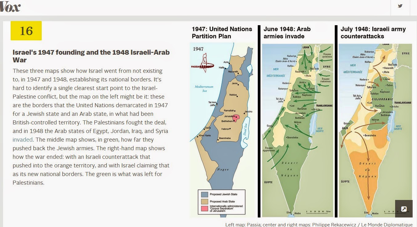
Last week I wrote about the use of the passive voice in describing the Nakba in the New York Times. This device allows for a sense of ambiguity as to who did what and specifically, who destroyed Palestinian villages. However, on May 16th this is how Jodi Rudoren described it: After two young Palestinian men were killed Thursday by Israeli security forces during a demonstration commemorating the Nakba — Arabic for “catastrophe,” and the word used to describe Israel’s destruction of Palestinian villages as it became a state in 1948 — two Israeli journalists said they were nearly “lynched” by a Palestinian mob.

Israel, Passive Aggression & the New York Times

By Yousef Munayyer

Arab villages were destroyed. The state of Israel destroyed Arab villages.

Do you see the difference there? The first sentence is in the passive voice and absent of any agency. Who destroyed the villages? We are not told in the first sentence. All we are told is that the villages “were destroyed.” The second sentence does not suffer from this ambiguity. It makes clear who the active agent is, in this case, the state of Israel, and that it “destroyed Arab villages.”

Palestine’s Scarred Landscape

By Yousef Munayyer

You might be thinking what can the chalk outline of a body and some rural green landscape possibly have in common. The answer: these images both depict crime scenes. If that seems very obvious for the picture on the right, but not for the image on the left, that is precisely the point. A great deal of effort has gone into hiding the crime on the left.

Explaining Max Fisher’s Missing Maps

By Yousef Munayyer

Over at Vox, blogger Max Fisher has a post up entitled “40 Maps That Explain the Middle East.” If such a title makes you cringe, you are not alone. Often these types of posts which attempt to provide context do more to obscure reality and explain the creator’s biases more than anything else. I am not going to dwell on each map. I won’t claim to know enough about the nuanced political and historical geography in every one of these maps to offer a detailed critique here. However, one thing I do know very well is the nuanced political and historical geography of Palestine and particularly the events around the Nakba. These events are supposedly represented by map number 16 on Max’s “explanatory” list entitled “Israel’s 1947 founding and the 1948 Israeli-Arab War.”